


exploratio Nd Garde

ego
User
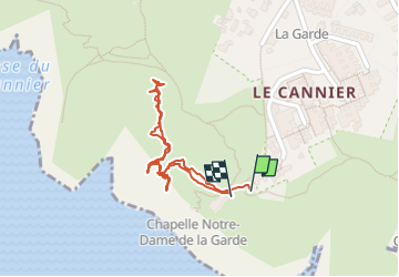

Length
960 m

Max alt
89 m

Uphill gradient
45 m
Km-Effort
1.5 km

Min alt
26 m

Downhill gradient
38 m
Boucle
Yes
Creation date :
2025-01-24 11:39:19.551
Updated on :
2025-01-24 13:37:53.649
1h57
Difficulty : Easy

FREE GPS app for hiking
 SityTrail
IGN / Geographical institutes
SityTrail Plus
The world is yours!
About
Trail Walking of 960 m to be discovered at Provence-Alpes-Côte d'Azur, Bouches-du-Rhône, La Ciotat. This trail is proposed by ego .
Description
débroussaillage
Photos


Positioning
Country:
France
Region :
Provence-Alpes-Côte d'Azur
Department/Province :
Bouches-du-Rhône
Municipality :
La Ciotat
Location:
Unknown
Start:(Dec)
Start:(UTM)
710769 ; 4782599 (31T) N.
Comments